2141 S. Airport Way - 1950s
Courtesy of Ron Chapman
Airport Way / Sharps Lane / Ophir / West Lane
Disclaimer! Informational page only, our practice limited to residential real estate.
I have created a series of pages covering the streets of Stockton. Scroll down the page or click on a link at the left to see another page. These pages grew put of my love for both architecture and photography. The old photos came from various sources such as The California Photo Library, Calisphere, Library of Congress, UOP Archives, USC Library. OAC Library, friends Facebook and many others. I literally photographed thousands of photos of Stockton buildings. I continue to photograph Stockton on an ongoing basis.
At the right of the page is an RSS feed, typically updated with fresh content hourly. Come back tomorrow and the topics covered will be different. I have included many topics on the various pages, including architecture, photography, books camera equipment reviews. Hover over the box at right? and you will find a browser bar to control the feed content. These pages are an ongoing project with changes being made regularly. Enjoy!
Airport is a North South Street originating in Manteca and continuing as West Lane half way to Lodi. At one time, Airport Way was Sharps Lane South of Charter Way and Ophir Street from Charter Way West to Harding Way. The names have been consolidated to Airport Way, South of Harding Way and to West Lane North of Harding Way
Click any thumbnail and it becomes a slideshow where you can then scroll through the slides. Or select Auto Play or use the mouse or keyboard arrow keys to scroll through all images
1415 S. Airport Way - Horseshoe Club
1420 S. Airport Way Roller Roost Skating Rink
1701 S. Airport Way - San Joaquin Golf Course
1805 S. Airport Way - Fairview Club (1976)
Airport Way and Eighth St. - 1960s - big Dipper Drive In - Left photo - SPD Archives
Airport Way and Eighth St. Ralph Square?
2141 S. Airport Way Former Red "D" Gas Station?
2141 S. Airport Way Former Red "D" Gas Station - Left photo by Ron Chapman - 1960?
2156 S. Airport Way - Breakfields Flying A?
2202 S. Airport Way - Airport Way Pharmacy (1976)/ Hunger's Rexall Drugs
2205 - Sharp's Lane Grocery
2219 S. Airport Way - AJ Liquor (1976) / Eddies Liquor Store No 3 (1960) / Pete's Liquors
2222 S. Airport Way - Thrones Variety & US Post Office Substation No 2
2226 S. Airport Way - Herbert's Shoes
2230 S. Airport Way - Bobson's Fairview Cleaners
2244 Sharpe Lane (S. Airport Way) Former Gaines Market / Uly's Market (1976) - Demolished - Right photo by Ron Chapman?
2305 S. Airport Way - Former Knowles / Jerry's Texaco?
2318 S. Airport Way Former Segarinis Market. ?Today a Grand Save Market.?
2323 S. Airport Way - Phil's Club Tavern
2326 S. Airport Way - Southeast Neighborhood Branch Library (1976) / Sierra Vista Laundromat
2332 S. Airport Way - Southeast Community Center (1976) / Sharps Lane Cleaners
2348 S. Airport Way - Walkers Shell / Shaeffers Shell Service
2410 S. Airport Way - US Post Office (1976) / Richfield Service
2525 S. Airport Way - Tri-valley Wholesale Dairy (1976) / Zellerbach Paper Co
2651 S. Airport Way - Sara Lee Bakery Outlet / Former Gravem-Inglis Sunbeam Baking Co.?
Stockton Metropolitan Airport?
North Airport Way Begins
Airport Way and 1304 E. Main St. Main Market?
Airport Way and 1305 E. Main St - La Victoria / Former Temme's Deli ?
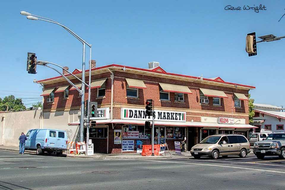
701 N. Airport Way - Danny's Market ?- Founded in 1957 / JC Balbi Grocery 1955, Jos Zappettini Grocery 1941
Corner of west Lane - Donuts To Go - 1506 West Lane - If the Donut on top of the building looks familiar, that's because it came from Mel Frances Rollin Doughnut at 901 N. Wilson Way?
3150 West Lane - West Lane Pet Hospital ?
Alpine and West Lane - New Ace Train Repair Facility?
1235 E. Alpine and West Lane - Former Used Car Lot / Gulf Station / Wilshire Station / A mom & Pop grocery store before that?
3200 West Lane at Alpine - Valero / Former Shell Station"> 3200 West Lane at Alpine - Valero / Former Shell Station?
3731 West Lane - Former Volvo Dealership / Imports of Stockton?
3750 West Lane - Royal Furniture - Former Harold W. Thompson?
3755 West Lane - Beberian Motors Mercedes Dealership?
3900 West Lane - West Lane Bowl?
3909 West Lane - OK Flowers?
4049 West Lane - Entenmann's Oroweat?
4206 West Lane - Deja Vu Erotic Ultra Lounge / Former Paradise Club / After the Casbah, it became Willie's and the crowd was predominantly gay / Little Trailer Concrete?
1209 E. March & West Lanes - Former Blockbuster Video?
1206 E. March & West Lanes - Shell Station / Former Union 76?
6262 West Lane - Holiday 8 Cinema?
6880 West Lane - Former Buffett Paradise / Former Tortilla Flats / The Elbow room in the 1960's. It later became Buffet Paradise - Porfie's was here for a short time too. Today the building is vacant?


Photo Location
2141 S. Airport Way - 1950s
Courtesy of Ron Chapman